DC Metro & Bus: WMATA Realtime
- 2.8
- Rating
- 500.00K
- Installs
- Free
- Price

 Analysis by App-foxy
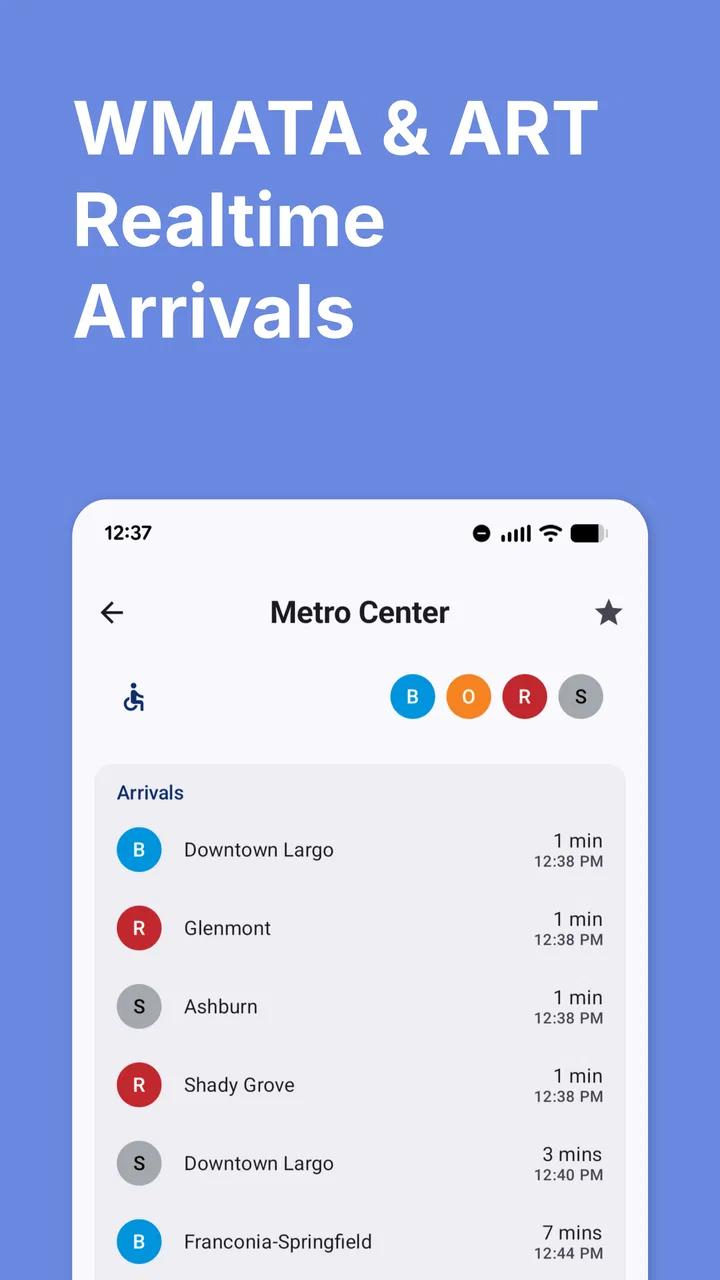
When I need to move around Washington, D.C. by rail or bus, I want answers that are useful in the next few minutes, not a long explanation of the entire transit system. DC Metro & Bus: WMATA Realtime is built around that immediate need. It is a free Maps & Navigation app from Dixon Mobility, LLC that brings train arrivals, bus tracking, trip planning, and an interactive map into one mobile tool. In my experience, its value depends heavily on whether the app can reach current transit information at the moment I need it, so connectivity is not a minor detail here; it shapes the whole experience.
The app is aimed at people using the Washington-area network rather than travelers looking for a broad city-navigation platform. That focus is its main appeal. Instead of treating public transportation as one option among many, it puts Metro trains and buses at the center. I found it most helpful when I already knew I wanted transit and needed to decide whether to wait, walk to another stop, or adjust my route.
How the app feels when every minute depends on a connection
The most important part of this app is the real-time layer. A route map can still be useful when nothing changes, but arrival information only earns its place on my phone when it reflects the current situation. If I am walking toward a station and checking whether a train is approaching, the answer has a short shelf life. The same is true when I am standing at a bus stop and deciding whether to remain there or walk to another nearby stop.
You May Also Like

 Blood Strike: 2.5 Anniversary
Blood Strike’s Loadouts Turn Every Drop Into a Tactical Gamble
A close look at Blood Strike’s custom loadouts: how fast access to signature weapons reshapes its battle royale rhythm, rewards preparation, and narrows the gap between fights.

 Pandora - Music & Podcasts
Pandora’s Music Is Easy to Start, but Harder to Recover
Pandora’s strength is its low-effort path from a seed to a station. Its weak spot is how much confidence it asks you to place in connection, setup, and quiet recovery.

 8 Ball Pool
 Is Built on Rivalries, Rematches, and Routine
A close look at the rivalries, rematches, shared routines, and unanswered safety questions that turn a quick pool match into a persistent mobile community.

 Samsung Music
’s Quiet Strength Is Playing What You Already Own
Its reach comes less from spectacle than from dependable access to a personal library. That simplicity is both the app’s strongest retention engine and its ceiling.

 AccuWeather: Weather Radar
AccuWeather Review: A Quick, Clear Forecast for Everyday Decisions
For everyday plans, the best forecast is the one you can understand quickly. AccuWeather makes rain timing, radar, and local conditions easy to act on, with a few trade-offs.

 Hill Climb Racing
Why Hill Climb Racing Still Turns Crashes Into One More Run
A tiny car, a bumpy hill and one more upgrade: Hill Climb Racing keeps resurfacing because its simple chaos makes every near-miss feel personal.
More From Our News Desk



That makes a stable mobile connection especially important. The app is designed around live arrivals and tracking, so I would not treat it as a complete replacement for planning ahead before leaving home. I prefer to open it while connected, review the route and upcoming service, and then keep a clear mental picture of the next step. If the signal becomes unreliable underground, between buildings, or in a crowded area, the experience can become less reassuring precisely when I want certainty.
This is not necessarily a flaw unique to this app. Real-time transit information has to come from somewhere, and current vehicle positions or arrival estimates cannot be refreshed without access to current data. Still, it changes how I use the app. I see it as a live decision tool rather than a guaranteed travel companion that can answer every question regardless of network conditions.
A practical habit is to check the next connection before entering a station or boarding a bus. I can confirm the direction, note the expected arrival, and remember the transfer point before the connection becomes difficult. That small step reduces the need to stare at the screen while moving through a station. It also gives me a fallback plan if the next refresh takes longer than expected.
Real-time information is most useful at decision points
The strongest use case is not browsing the map for entertainment; it is making a choice. Should I wait for the next bus, walk toward a rail station, or change the route before I commit to a transfer? The combination of arrival information, bus tracking, and trip planning gives me several pieces of that decision in one place.
For example, imagine leaving work with a nearly empty phone battery and a meeting across town. I can use the trip planner while I still have a reliable connection, check the first train or bus, and identify the transfer that matters most. If the first leg is delayed, the live information may help me reconsider the plan before I spend time walking to the wrong platform. That is a more useful workflow than opening a general map and treating every transit estimate as equally dependable.
The interactive map also helps with orientation. I like having a visual reference when a stop name is unfamiliar or when several lines and bus corridors overlap. However, a map is not automatically the fastest way to understand a trip. I usually begin with the planner for the sequence of steps, then use the map to verify where I am going. Starting with the map alone can lead to unnecessary zooming and searching, especially on a small phone.
One less obvious advantage of combining these tools is that it supports a two-stage check. First, I can plan the broad journey. Then, close to departure, I can use live arrivals to decide whether the original timing still makes sense. That distinction matters because a route can remain logically correct while the immediate departure becomes inconvenient.
Using it while walking, waiting, and transferring
On a phone, context matters as much as the feature list. At home, I have time to enter a destination and compare options. On a sidewalk, I need a quick glance. At a bus stop, I care about the next departure more than a complete overview. During a transfer, I want to confirm that I am still moving in the intended direction without losing track of the next step.
I would therefore avoid trying to do all planning while already in motion. Before walking, I check the route and identify the stop or station I need. While waiting, I use the live information to reassess timing. During a transfer, I focus on confirming the line or direction rather than rebuilding the whole journey. This approach makes the app feel less demanding and reduces the effect of a temporary connection delay.
The app is also better suited to people who already understand the basic shape of the local system. A first-time visitor can still benefit from trip planning and the map, but unfamiliar station names and transfers may require extra attention. A general navigation service may offer more walking guidance or combine transit with driving and cycling in a broader way. I would choose this app when the Metro and bus network is the main subject, not when I need one universal planner for every transportation mode.
What happens when the signal, timing, or plan breaks down
Transit rarely follows the neat sequence shown in a planned itinerary. A bus may arrive later than expected, a transfer may become awkward, or I may decide to leave at a different time. The app’s usefulness during those moments depends on how quickly I can recover from the original plan rather than on whether the first route was perfect.
My preferred recovery method is simple: return to the current location or nearby stop, check the next available option, and rebuild only the affected portion of the trip. I do not start over unnecessarily. If the first bus is the problem, I look for the next departure or an alternative connection. If the transfer is no longer practical, I use the planner again from the point where the journey changed.
This is where connectivity can create friction. A delayed refresh can make an old estimate look more useful than it really is, particularly if I am in a hurry. I try to treat any live time as a snapshot, not a promise. After moving through a station or leaving a building, I refresh when possible and compare the result with what I can see around me.
A useful fallback is to remember the destination and the main transfer before the trip begins. That does not make the app unnecessary; it simply prevents a blank or slow-loading screen from turning into total confusion. I also keep the route’s direction in mind, because knowing whether I need an inbound or outbound service can be more valuable than remembering every stop.
The experience is less comfortable for someone who expects a navigation app to continuously guide every footstep. This tool is centered on DC Metro and bus information, so I would not rely on it alone for detailed pedestrian instructions through a large complex, a confusing venue, or an unfamiliar neighborhood. In those situations, a broader navigation app can complement it better than replacing it entirely.
Planning before the journey is the best recovery strategy
Although the app is designed for current transit information, I get better results when I use it before the rush begins. I can examine the route, notice whether a transfer is unavoidable, and decide how much flexibility I need. Then, when the actual departure approaches, I only need to verify the live portion instead of exploring every possibility under pressure.
This workflow is particularly useful for appointments. I can plan from the starting point, identify the station or bus stop that controls the schedule, and leave enough room for walking and transfers. If the live departure changes, I already know which part of the route deserves attention. The app becomes a checkpoint system: plan first, verify second, adjust only where necessary.
For regular commuters, the same method can make repeated trips less tiring. I would not repeatedly rebuild a familiar route from scratch. Instead, I use the app to check the departure that matters today and to monitor whether the usual timing is still sensible. That saves attention and makes the live features more meaningful than simply opening the map every time.
Using the app without wasting mobile data or battery
Because this is a live transit app, frequent checking can consume more connectivity and battery than a single route lookup. I do not leave it open continuously unless I truly need to watch a changing situation. I check the route before leaving, look again near the departure point, and refresh after a meaningful change such as reaching a station or completing a transfer.
That pattern is more efficient than repeatedly refreshing while standing still. It also helps me distinguish useful updates from nervous checking. If the bus is not due for several minutes, looking again every few seconds is unlikely to improve the decision. I would rather use one check to confirm the next action, then put the phone away.
On a limited data plan, I would be especially selective with the interactive map. The map is valuable for orientation, but I do not need to keep moving around it once I know the stop or station. The trip planner and arrival view are usually more relevant to the immediate journey. I also avoid making a long route plan in a weak-signal location when I could do the preparation earlier on a stronger connection.
Battery management matters for the same reason. A phone that reaches the destination with no charge is not much help on the return trip. I use the app to answer specific questions rather than as a constantly visible dashboard. Saving a mental note of the major transfer and direction is a small but effective way to reduce screen time.
There is a trade-off here: checking less often saves resources, but checking too little can leave me working from stale information. The right balance depends on the journey. For a short, familiar ride, one or two checks may be enough. For a trip with several transfers or a tight arrival time, I check at each important decision point while avoiding unnecessary map browsing.
What the app costs and who can use it
The app itself is free, which makes it easy to try without committing money upfront. It is rated for Everyone, so its intended audience is broad, from occasional visitors to daily riders. Dixon Mobility, LLC maintains the app, and the current release is version 4.0.62. It has been available since October 20, 2012, and its long presence is relevant for anyone looking for a focused local transit tool rather than a newly launched experiment.
There are in-app purchases ranging from $1.99 to $23.99 per item. I would pay attention to the purchase screen before confirming anything, especially if I only need basic arrival checks. The free entry point is a strong reason to test the app during a normal commute, but the presence of optional paid items means I would not assume every extra function is included without reviewing what is offered in the app.
The store audience is substantial, with over 500 thousand installs, yet the average rating is 2.8 from around 7 thousand ratings and roughly 2 thousand reviews. I read that combination as a reason to set expectations carefully. The app clearly has a real user base, but it is not a universally smooth experience. For me, the rating reinforces the need to test it in the exact places and situations where I plan to use it, particularly around weak connectivity and time-sensitive trips.
Where it fits beside broader navigation apps
A general map app is often better when I need walking directions, a business search, driving alternatives, or several transportation modes in one result. Those services may feel more polished for exploring an unfamiliar area. They can also be preferable when the journey begins or ends far from a Metro station and the transit leg is only one part of a larger plan.
DC Metro & Bus: WMATA Realtime makes more sense when the local rail and bus network is the main problem to solve. Its focus keeps the relevant information closer to the surface: arrivals, bus movement, route planning, and a transit-oriented map. I do not have to sort through restaurant pins or driving suggestions before reaching the information I actually want.
I would use both types of app when necessary rather than forcing one to do everything. A broad navigation tool can handle the walk from a hotel or office, while this app can provide the transit-specific view. The trade-off is having to switch between tools, but that can be worthwhile when each one is strong in a different part of the journey.
It is also not the right choice for someone who wants a fully disconnected travel plan. Since its central appeal is current arrival and tracking information, I would not choose it as my only safety net for a long trip through areas where I expect poor reception. I would prepare the route while connected and keep basic directions in mind, then use the app for live confirmation when the network allows.
My connectivity verdict after using it in realistic situations
I see this as a practical specialist rather than a complete travel assistant. Its best moments happen when I am already near the DC Metro or bus network, have a working connection, and need to make a quick choice about timing or routing. The combination of live arrivals, bus tracking, trip planning, and an interactive map gives the app a clear purpose.
Its limitations are equally clear. A weak signal can undermine the very information that makes it valuable, and frequent refreshing is not a sensible habit for every trip. The modest average rating also suggests that I should approach it as a tool to test, not an automatic guarantee of a smooth commute. I would keep a simple fallback in mind and avoid depending on one live screen for a critical appointment.
For a daily rider, the free price makes experimentation easy, and the focused design can be more convenient than a general-purpose map when the question is simply, “When is my next train or bus, and what should I take?” For a visitor, it can be helpful if the trip is mainly within the Washington transit system, though a broader navigation app may still be better for walking and sightseeing.
My recommendation is to use it as a connected, decision-focused companion. Open it before departure, identify the important transfer, check live information at the moments that can change your plan, and avoid treating every estimate as permanent. If that matches the way you travel, this app is worth trying. If you need dependable guidance without a network connection or one app that handles every mode and every walking detail, I would choose a broader alternative and use this one only as a transit-specific supplement.
FAQs for DC Metro & Bus: WMATA Realtime
01What is DC Metro & Bus: WMATA Realtime?
DC Metro & Bus: WMATA Realtime is a transit companion app for Washington, D.C., Maryland, and Virginia. It helps riders check Metrorail and Metrobus information, view nearby stations and stops, review route details, and access estimated arrival times when real-time data is available. It is designed for everyday commuting, trip preparation, and quickly checking service information while traveling around the WMATA network.
02Does the app provide real-time Metro and bus arrival information?
The app is built around WMATA transit data and can display estimated train and bus arrivals for supported stations and stops. Actual accuracy depends on the information supplied by WMATA, vehicle tracking availability, network connectivity, and unexpected service conditions. Arrival predictions should therefore be treated as estimates rather than guarantees, especially during delays, incidents, severe weather, or periods when live data is temporarily unavailable.
03Can I use DC Metro & Bus: WMATA Realtime to plan a complete trip?
The app can be useful for checking routes, stations, stops, and arrival information, but its trip-planning capabilities may not replace a full navigation service in every situation. Before starting a journey, riders should confirm the selected line or bus route, transfer points, direction of travel, and any service alerts. For complex trips, comparing the app’s information with official WMATA notices or another navigation tool is recommended.
04Does the app require an internet connection or location access?
An internet connection is generally needed to retrieve updated arrival predictions, service information, and other live transit data. Location access may be useful for finding nearby Metro stations or bus stops, although many features can often be explored by searching manually. If you are underground, outside cellular coverage, or using the app with connectivity disabled, live information may be delayed, incomplete, or unavailable.
05Is DC Metro & Bus: WMATA Realtime official, and should I rely on it during disruptions?
Users should check the app’s store listing and publisher information to determine whether it is an official WMATA application or an independent app that uses WMATA data. Even when the displayed information is helpful, major disruptions can change quickly, so riders should also consult official WMATA announcements, station personnel, or posted alerts. Keep in mind that schedules and predictions are not a substitute for current safety instructions.
Pros
- Live train arrivals help reduce waiting time at stations.
- Bus and rail information is combined in one convenient app.
- Station details make it easier to plan transfers and connections.
- Useful for checking service changes while traveling around Washington
- D.C.
- Simple route planning supports both regular commuters and visitors.
Cons
- Realtime estimates can become inaccurate during major disruptions.
- Some features may depend on a stable mobile data connection.
- The interface may feel dated compared with newer transit apps.
- Crowded results can make complex multi-transfer trips harder to follow.
- Coverage is focused on WMATA services rather than regional transit networks.

DC Metro & Bus: WMATA Realtime
Gallery